327 islanders in 1841. Just 85 recorded ten years later.
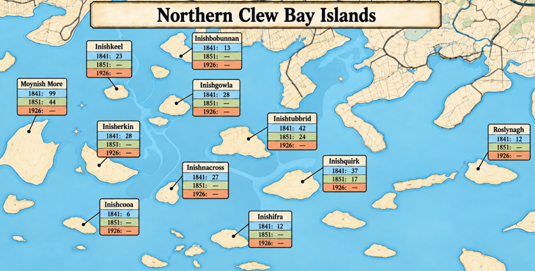
Looking out across the northern reaches of Clew Bay today, it is difficult to imagine that many of its small, seemingly deserted islands once supported thriving communities.
Yet the census of 1841 tells a remarkable story.
On just eleven islands between the Mulranny coastline and Newport Bay, 327 people lived in 55 occupied houses. These were established settlements where families raised children, tended livestock, cultivated small plots of land and depended on boats for their connections with neighbouring islands and the mainland.
Some of these communities had histories stretching back centuries. According to Griffiths Valuation all of these islands were owned by a Henry Jeremiah Smith Jr.
Smith’s portfolio made him one of the biggest landowners in the Burrishoole parish area and the residents of the islands paid their rent to him. Smith’s property acquisition links him to several established landed families.
The Smith family’s principal residence was Beabeg, near Drogheda, County Meath. There were at least three generations of Henry Jeremiah Smiths.
In 1861, he advertised his Newfield estate, comprising 8,277 acres, for sale through the Landed Estates Court. The McLoughlins had previously held land under long-term arrangements involving the Medlycotts, the Brownes (Marquesses of Sligo) and the O’Donels of Newport. By 1876, most of the former estate was owned by the Gibbings family.
This creates a documented historical connection between Smith’s Newfield purchase and estates formerly associated with those families. But it does not prove that the islands themselves were acquired directly from the Marquess of Sligo. The question is what was Smith’s role, if any, in the depopulation of the islands?
THE ISLANDS AND THEIR INHABITANTS
Moynish More — 99 inhabitants
The largest community among these eleven islands, Moynish More supported 99 people living in 18 houses in 1841. This was a substantial settlement by the standards of the smaller Clew Bay islands.
By 1851, its population had fallen to just 44. By 1901, the McIntyre family was among the last families recorded there.
Inishtubbrid — 42 inhabitants
Five occupied houses accommodated 42 people in 1841. Ten years later, only 24 inhabitants remained.
The community survived into the twentieth century. In 1911, eleven people bearing the McHale surname were recorded on the island.
Inishquirk — 37 inhabitants
Six houses accommodated 37 people in 1841. By 1851, only 17 people remained.
The island’s population had fallen by more than half during the Famine decade.
Inishgowla — 28 inhabitants
This is the Inishgowla situated towards the northwestern part of the bay, not the separate island of the same name nearer Westport.
The 1841 census recorded fourteen males and fourteen females living in four houses.
By 1851, no inhabitants were recorded.
Inisherkin — 28 inhabitants
Perhaps one of the most fascinating islands in this group.
Inisherkin supported 28 people living in five houses in 1841.
The old Ordnance Survey maps show a house on the eastern side of the island, sheltered to some extent from the prevailing Atlantic winds. A later account describes the remains of this dwelling and notes that little evidence of the other houses survives.
Even more interestingly, Inisherkin contains the remains of a substantial ringfort, suggesting human occupation or activity on the island many centuries before the nineteenth-century families lived there.
The ringfort and the later house site are both situated towards the eastern end.
By 1851, the census recorded no inhabitants.
Inishnacross — 27 inhabitants
Six occupied houses stood on this small island in 1841, accommodating 27 people.
Remains of former houses have been reported, together with what appears to be an artificial landing area on the eastern side.
Such a landing place would have been particularly important to a small island community whose connections with the outside world depended on boats.
No inhabitants were recorded in 1851.
Inishkeel — 23 inhabitants
Twenty-three people lived in three houses on Inishkeel in 1841.
Like nearby Inisherkin, the island contains the remains of an ancient ringfort, indicating a much earlier phase of human settlement or activity.
The presence of a ringfort does not necessarily indicate continuous occupation through the centuries, but it demonstrates that these small islands were significant long before the nineteenth century.
By 1851, no residents were recorded.
Inishbobunnan — 13 inhabitants
Two houses accommodated thirteen people in 1841.
This suggests a very small community, possibly consisting of one or two extended families, although the published census does not identify their names.
No population was recorded in 1851.
Inishilra — 12 inhabitants
One of the most poignant examples.
Twelve people lived in a single house on Inishilra in 1841.
The remains of a ruined dwelling have been reported on the island. It may be connected with the household recorded in the census, although that identification has not been established.
By 1851, no inhabitants were recorded.
Roslynagh — 12 inhabitants
Roslynagh supported twelve people living in three houses in 1841.
Recently, someone whose family owned part of the island contacted this page and described stone walls near its eastern point.
Historical Ordnance Survey maps also show a building on Roslynagh.
These observations raise an intriguing possibility: that some physical evidence of the island’s nineteenth-century settlement still survives.
By 1851, the census recorded no inhabitants.
Inishcooa — 6 inhabitants
One of the smallest settlements in the group, Inishcooa had six inhabitants living in two houses in 1841.
The census records no population there ten years later.
THEN CAME THE GREAT FAMINE
The Great Irish Famine began in 1845, just four years after the 1841 census.
The potato crop failed repeatedly, and the following years brought starvation, disease, evictions, emigration and the displacement of entire communities throughout the west of Ireland.
The 1851 census reveals the scale of the changes on these eleven islands.
Of the original 327 inhabitants, only 85 were recorded ten years later, living on Moynish More, Inishtubbrid and Inishquirk.
The other eight islands, which had supported 149 people in 1841, had no inhabitants recorded in 1851.
If those blank returns indicate that the islands were uninhabited, this represents a population decline of approximately 74% in just ten years.
But what happened to those 242 people?
The census cannot tell us how many died, how many emigrated, or how many simply moved to the mainland or neighbouring islands.
Nor can we assume that every settlement disappeared solely because of the Famine.
What we can say is that a way of life that had existed on these islands for generations underwent an extraordinary upheaval during that decade.
THE EVIDENCE THAT REMAINS
The islands themselves still hold clues to their former inhabitants.
The ringforts on Inisherkin and Inishkeel point to much earlier human activity.
Old Ordnance Survey maps reveal former dwellings, field boundaries and other features of the landscape.
Ruined houses and stone walls survive, or have been reported, on islands including Inisherkin, Inishnacross, Inishilra and Roslynagh.
These are more than abandoned buildings. They are physical reminders of the families whose names have largely disappeared from the historical record.
Unfortunately, most original household returns from the 1841 and 1851 censuses were destroyed in 1922, meaning we cannot easily identify the people who lived in these houses.
However, we are investigating the Marquis of Sligo estate rental records held by the National Library of Ireland, including ledgers from 1844 to 1851.
These may contain the names of tenants and, potentially, evidence of deaths, emigration, arrears, evictions or abandoned holdings during the Famine years.
CAN YOU HELP RECOVER THEIR STORIES?
Perhaps the most valuable information will come from people whose families retained connections with these islands.
Do you know of ruined houses, abandoned fields, landing places, old family burial grounds or stories associated with any of the eleven islands?
Were your ancestors among those who lived there?
We would be particularly interested in photographs, family names, old documents or recollections concerning Moynish More, Inishtubbrid, Inishquirk, Inishgowla, Inisherkin, Inishnacross, Inishkeel, Inishbobunnan, Inishilra, Roslynagh and Inishcooa.
In 1841, these islands were home to 327 people. Their communities deserve to be remembered.
Sources: Census of Ireland 1851, County Mayo, Burrishoole parish, p. 120 (retrospective 1841 and 1851 returns); historical Ordnance Survey mapping; published accounts of island archaeology and local history.
#ClewBay #MayoHistory #GreatIrishFamine #NewportBay #IrishIslands #IrishGenealogy
Please contact [email protected] if you have a connection or something to share.
References
Croagh Patrick and the Islands of Clew Bay
Secure checkout powered by WooPayments. Payment details are processed securely and are not stored on The Reek website.
Related Posts
- Islandmore and Knockycahillaun: A Connected Community, Remembered Across Generations
- Who held the deeds to the islands after the famine?
- When the Islanders of Clew Bay Defied Lord Sligo: The Rent Revolt of 1887
- The Forgotten Communities of Northern Clew Bay
- The Disappearing Island Communities of Clew Bay: 1901–1926
- The Islands and Maritime History of Westport Bay
- Where did the people of Newport Bay’s Islands go?
- Inishlyre – The Clew Bay Island that welcomed the world